Satellite Images Reveal How Unchecked Construction Along Neelum River Raised Flood Risk in Muzaffarabad
Official satellite imagery released through SUPARCO’s Space4Climate platform has highlighted how rapid and largely uncontrolled urban development along a tributary of the Neelum River has significantly increased flood risk in Muzaffarabad over the past two decades.
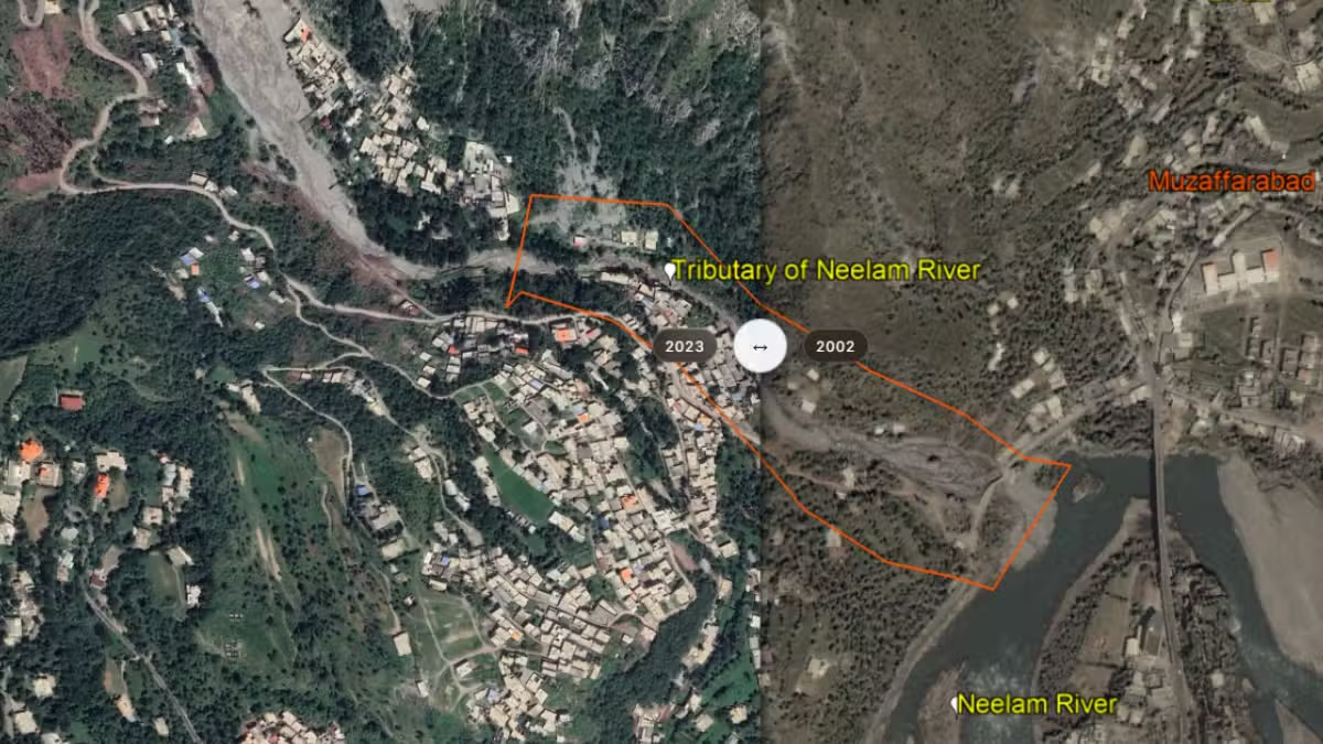
The satellite-based assessment compares images captured in 2002 and 2023, revealing a dramatic transformation of the landscape. Large open areas that once allowed floodwaters to spread naturally have gradually been replaced by dense residential and commercial developments, leaving surrounding communities more exposed to flooding during periods of heavy rainfall.
According to the analysis, continuous construction along the tributary has narrowed its natural channel, reducing the amount of space available for water to flow safely. As a result, intense rain events now pose a greater threat to nearby neighborhoods, increasing the likelihood of flash floods and water overflow.
The findings were published on Space4Climate, a web portal powered by the Pakistan Space and Upper Atmosphere Research Commission (SUPARCO). The platform uses satellite technology to monitor environmental changes, climate impacts, and land-use patterns across the country.
The comparison between the 2002 and 2023 satellite images clearly illustrates how urban expansion has altered the natural floodplain. Areas that previously acted as buffers during high water levels have been replaced by buildings, roads, and other infrastructure, limiting the tributary’s ability to manage excess water during storms.
Experts have long warned that unplanned urbanization along rivers and streams can increase disaster risks by obstructing natural drainage systems. When waterways become constricted, even moderate rainfall can trigger flooding that affects homes, businesses, and public infrastructure.
The satellite assessment underscores the importance of integrating climate resilience into urban planning. As Pakistan continues to experience more frequent extreme weather events linked to climate change, protecting natural waterways and preserving floodplains has become increasingly important for reducing disaster risks.
The report also demonstrates the growing role of satellite technology in environmental monitoring and disaster management. By tracking changes in land use over time, satellite data provides policymakers and planners with valuable insights that can help guide future development while minimizing risks to communities.
The latest findings serve as a reminder that sustainable urban planning is essential for balancing development with environmental protection. Preserving natural water channels and enforcing land-use regulations can play a crucial role in reducing flood hazards and improving resilience in vulnerable regions such as Muzaffarabad.