Satellite Images Suggest Iran Damaged 20 US Military Sites Across Middle East During Conflict
New satellite imagery analysis has revealed that Iran may have caused significant damage to at least 20 United States military sites across the Middle East during the recent conflict, raising questions about the true scale of the attacks and their impact on regional security.
According to reports based on satellite images and video evidence reviewed by independent analysts, the affected facilities were spread across several countries, including Saudi Arabia, the United Arab Emirates, Qatar, Kuwait, Iraq, Jordan, Bahrain, and Oman. The findings suggest the damage may be more extensive than previously acknowledged in official statements.
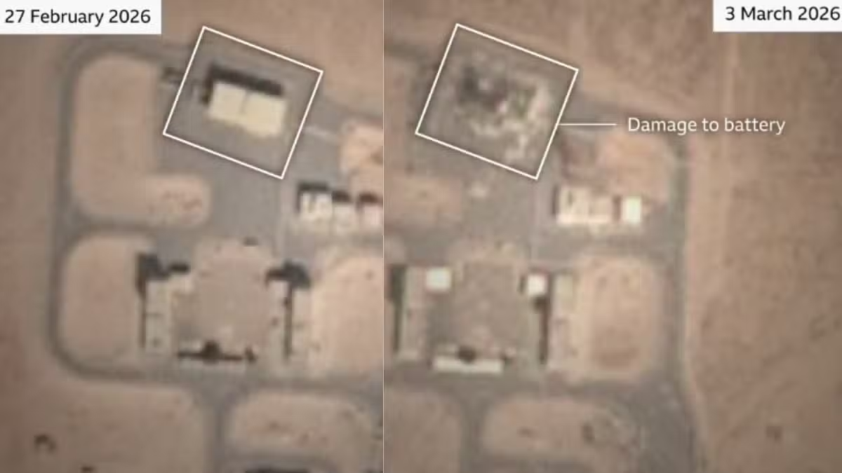
The analysis, reportedly conducted using imagery from multiple international satellite providers, identified strikes on a range of strategic military assets. These included air defense systems, radar installations, fuel storage facilities, aircraft hangars, communications equipment, and military support infrastructure.
Among the reported losses were advanced missile defense systems stationed at key military bases in the Gulf region. Analysts also highlighted visible damage to refueling aircraft and surveillance platforms, with satellite images showing burn marks, destroyed structures, and damaged equipment at several locations.
The findings have fueled debate over the effectiveness and reach of Iran’s retaliatory capabilities during the conflict. While US officials have repeatedly emphasized that Iran’s military infrastructure suffered major setbacks during the war, satellite-based assessments indicate that Iranian counterstrikes may have inflicted substantial damage on American facilities across the region.
Reports suggest that several sites in Kuwait sustained heavy damage, including fuel storage areas, troop facilities, aircraft shelters, and communications systems. Defense analysts reviewing the imagery noted signs that some installations may have been struck multiple times throughout the conflict.
The broader conflict began earlier this year and triggered military exchanges involving the United States, Iran, and regional allies. Since then, tensions have remained high despite ceasefire efforts and ongoing diplomatic discussions aimed at reducing hostilities.
Satellite imagery has increasingly become an important tool for assessing military activity and battlefield damage, particularly in situations where access to conflict zones is limited. Independent analysts often use commercial satellite data to verify claims made by governments and military organizations.
While officials have not publicly confirmed the full extent of the reported damage, the latest analysis highlights how modern satellite technology is providing new insights into military conflicts and strategic operations across the Middle East. As more imagery becomes available, further assessments may offer a clearer picture of the long-term impact of the strikes on regional military infrastructure.